
25 September 2019
The Mirpur earthquake in Pakistan: images of lateral spreading
Posted by Dave Petley
The Mirpur earthquake in Pakistan: images of lateral spreading
On 24th September 2019 an M=5.6 earthquake struck Mirpur in NW Pakistan. Whilst the Mirpur earthquake was comparatively small, it was also shallow, meaning that a significant area will have suffered high peak ground accelerations. The USGS has generated a map of earthquake intensity (the contours on the map), enhanced by the shading, which shows areas of liquefaction potential:-
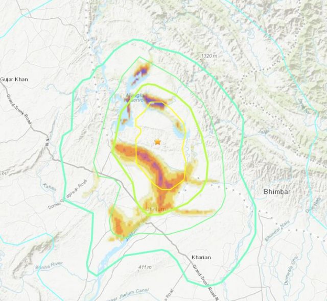
A map of earthquake intensity and liquefaction potential for the 24th September 2019 M=5.6 Mirpur earthquake in Pakistan. Map via the USGS.
.
At the time of writing, over 30 people have been reported to have been killed, whilst at least 450 people were injured. Interestingly, the area with the highest intensity of shaking coincides with both the banks of the major Jhelum River and the margins of part of the huge Mangla reservoir:-
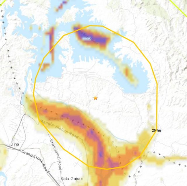
A map of earthquake PGA and liquefaction potential for the 24th September 2019 M=5.6 Mirpur earthquake in Pakistan. Map via the USGS.
.
Thus, whilst this earthquake is not large, it has the potential to generate both liquefaction and lateral spreading. Early images coming out of Pakistan show that the earthquake has had just this effect. For example, this image (from the Independent), clearly shows lateral spreading on the banks of the river. Note that the material appears to be made ground:-
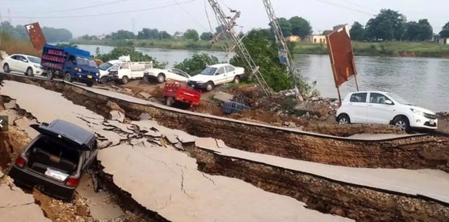
Lateral spreading from the Mirpur Earthquake in Pakistan. Image via the Independent.
.
Whilst this image, also from the Independent, also appears to show this area of lateral spreading:-
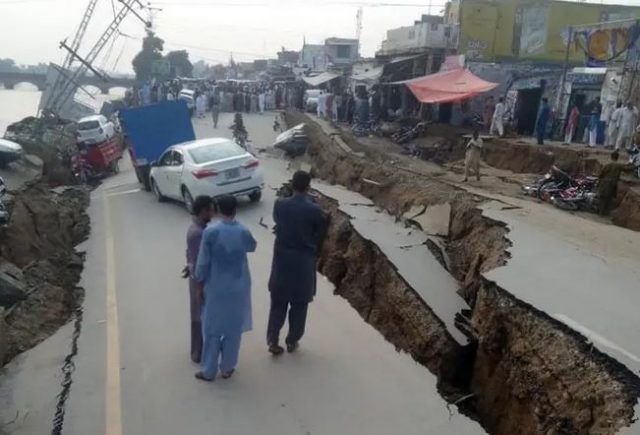
Lateral spreading from the Mirpur Earthquake in Pakistan. Image via the Independent.
.
As usual, it is difficult at the moment to ascertain the full extent of these types of impacts – this should become apparent in the days ahead. It will also be interesting to find out the proportion of the building collapses that are associated with these lateral spread events, rather than simple structural failure under high peak ground accelerations.
 Dave Petley is the Vice-Chancellor of the University of Hull in the United Kingdom. His blog provides commentary and analysis of landslide events occurring worldwide, including the landslides themselves, latest research, and conferences and meetings.
The two pictures are two different angles of the same scene, perhaps from 150 degrees angular separation.
You’ve certainly been very busy lately here at your Landslide Blog, Dave!
I’m just an ametuer geomorpholgy enthusiast, fascinated with gravity’s influence on high-relief topography.
Over the last few years, your analysis’, interpretation and commentary essays have contributed more than any other resource, in broadening my understanding, enabling an insight….and inspiration to explore landscapes that are the result of, or threaten to initiate substantial mass-wasting.
Thank you, sincerely, for your seemingly tireless efforts in sharing your comprehensive expertise!
[Thanks you, that is very kind indeed, and much appreciated. D.]
The Mirpur earthquake in Pakistan. magnitude 5.6. there are 19 people are died in Kashmir and 300 injured. The prime minister of Pakistani Kashmir told that infrastructure had been destroyed. I think to start a community from https://www.couponswebdeal.com/store/hostgator/. join people with us and help the citizens.
Parece que los daños están asociados a una franja paralela a la rivera donde la propagación de la onda puede tener otros factores que amplificaron el efecto del sismo.
Seria interesante profundizar sobre estructuras presentes o saturación de lechos permeables.
A very devastating earthquake which was not big in magnitude but left destruction everywhere. Since then it has been three big after shocks and one more is reported today as well. This area seems to be going through some kind of change underground. Speculations are that it could have been consequence of Mangla Dam upraising.
Most probably these are induced events. Besides Mangla Reservoir, the other contributing factor might be several dozen stone crushers operating within 5km downstream of the main spillway for more than 10-12 years. Stone and sand weighing millions of tones have been removed from surrounding of main dam and this is the area from where material removal was strictly prohibited by the dam builders.
A splendid article you shared to us. What a fantabulous post this has been. Never seen this kind of useful post. I am grateful to you and expect more number of posts like these. Thank you very much.
nice bLog! its interesting. thank you for sharing…. slot gacor
never forget the day that i found this site , really amazing content you have
Great write-up, I am a big believer in commenting on blogs to inform the blog writers know that they’ve added something worthwhile to the world wide web!..
Thank you for the update, very nice site.