Editor’s note: This post about the anthropogenic causes of flooding was written by Steve Grimmer, Artist Mechanic at Little River.

The Mississippi River at 42.4 feet on Monday, May 27, 1943, in downtown Cape Girardeau, Missouri. Flood stage is 32 feet. (Photo credit unknown. Ken Steinhoff)
River scientists, conservationists, and consultants who work ‘in the field,’ have for a long time understood, both from an intuitive and an observational point of view, that river flood events are driven by more than just rainfall, groundwater, and geomorphology. Anthropogenically (ie, caused by humans) introduced factors such as channelization, levees, and other flood-management schemes have a large effect on frequency and severity of floods. As a recent article in the AGU’s journal Eos explains, a multi-disciplinary approach to the problem will be necessary to more fully understand and predict the frequency and severity of major flood events. Assessing the problem solely through the lens of climate change and increased rainfall is insufficient.
Many models have assumed a static river conveyance capacity (the rate at which a river carries water) for predicting floods, relying solely on hydrological inputs, such as precipitation and inflow. But increasing efforts by humans to manage rivers and to protect property mean single-input models are becoming less useful. River management schemes don’t change how much water is coming down the channel, but they do affect where the water goes and where it eventually tops the banks.
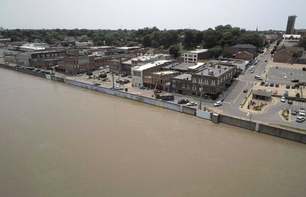
The Mississippi River at 44.35 feet on Monday, June 3, 2019, in downtown Cape Girardeau, Missouri. Flood stage is 32 feet. Flood walls can lend invaluable protection where they are placed, but have consequences for others up and downstream. (FRED LYNCH ~ Special to the Southeast Missourian)
Rivers and streams will find an equilibrium state and settle into a particular channel geometry and meander plan based on factors such as flow, slope, landform, sediment load, and bank characteristics like permeability and erosion resistance. Flooding throws this equilibrium out of balance, often causing changes to the shape and plan of the river that are revealed as waters recede.
The next flood event has a different river to flow through, so to speak, throwing previous calculations out of whack. In this sense as the authors put it, “fluvial systems have ‘memories.’” Adding to the complexity, human-introduced changes to the channel and nearby lands, whether inadvertent or as flood mitigation efforts, mean that each flood is not simply a product of a particular hydrograph, but a complex interaction of factors. It turns out that there is a feedback loop to many of our river engineering efforts, in that changing a river to our needs can often cause the river to exhibit more of the behavior we were attempting to mitigate.
The authors argue that we need historical flood analysis both through hydrological records and study of old channels and floodplain deposits. We must combine this with study of previous attempts at flood defense, and with contemporary input from surveyors, engineers, hydrologists, climate scientists, and geomorphologists to yield insights into new and intelligent ways of buffering our society from flood damage.
At Little River Research and Design, we believe we must use this new interdisciplinary approach to also benefit the rivers themselves so that they are healthier and can continue to contribute to our society’s ecological, agricultural and transportation needs. Our Emriver stream tables, along with our Structures Kit, can help you understand and demonstrate the interaction between human-placed river interventions and flood behavior.


