Mapping the Interior of the Earth
A correspondent has sent me THIS LINK. The article is based on THIS PAPER. The original authors have used seismic shear waves that diffract along the core mantle boundary to identify what they call "Ultra-Low Velocity Zones" (ULVZ); in addition they say that they can detect variability within the ULVZ.
These ULVZ are only a few tens of kilometres high, and, being on the core mantle boundary, are very difficult to study. But high frequency waves allow them to see inside the zones.
There is a ULVZ beneath Hawaii (also, Iceland, Samoa and the Marquesas) and they postulate that they are iron enriched (possibly by interaction with the core).
And they note that ULVZ are associated with hotspots.
There is a lot in these papers. We seem to be in a period when we are finding more and more about the Earth's interior - exciting times!
Below is a diagram illustrating the seismic techniques. I like the use of beachballs!
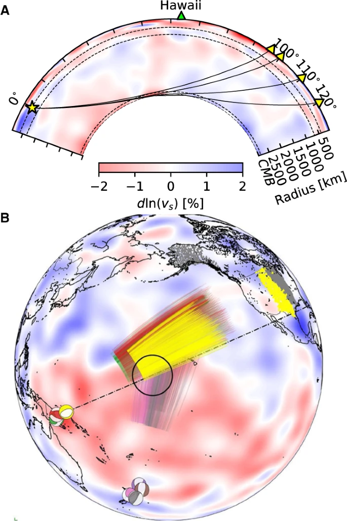
A Cross-section slicing the center of Hawaiian ultra-low velocity zone, showing ray paths of Sdiff waves at 96°, 100°, 110°, and 120° for 1D Earth model PREM49. The dashed lines from top to bottom mark the 410 km, 660 km discontinuity, and 2791 km (100 km above the core–mantle boundary). B Events and Sdiff ray paths on the background tomography model SEMUCB_WM1 at 2791 km depth50. Beachballs of events plotted in different colors including 20100320 (yellow), 20111214 (green), 20120417 (red), 20180910 (purple), 20180518 (brown), 20181030 (pink), 20161122 (gray), stations (triangles), and ray paths of Sdiff waves at pierce depth 2791 km in the lowermost mantle used in this study. The event used in short-period analysis is highlighted in yellow. Proposed ULVZ location is shown in black circle. Dashed line shows cross-section plotted in A.
No comments:
Post a Comment